At a glance
Pashtuns call the Indus Abasin (اباسين), "the Father of Rivers". H. G. Raverty's Pashto dictionary of 1860 lists it as abā-sīn, or abā-sind, from abā, "father", and sīn or sind, "a river". [1]
The poets use the name: Rahman Baba and Hamid set the river in a verse, and Khushal Khan Khattak calls to it from Hind. [2]
The river is an eastern edge of the Pashtun country, but an uneven one. In 1815 Mountstuart Elphinstone gave the Indus as the Afghans' eastern boundary only while it runs near the hills, and Khushal wrote that the Afghans "from Kandahar unto Attak" stand together. [2, 3]
Akbar ordered the fort at Attock in June 1581. It stands on the east bank, facing Khairabad, where the Kabul river joins the Indus. [4, 7]
Pashtun villages lie on both banks. Many of the eastern ones, in Mianwali especially, had given up Pashto by the early twentieth century. [4–6]
Two dams on the river touch Pashtun districts: Tarbela, built from 1968 to 1976, whose displaced villagers were still being resettled in 2002 and 2016, and Kalabagh, proposed in 1984 and never built. [8, 9, 11, 12]
Abasin, the father of rivers
Raverty's entry gives the word in Pashto script, اباسين, with a second spelling, ابا سيند, and defines it as "the Father of Rivers, the Afghān name for the Indus". [1] The last part is the Pashto word for a river. The same dictionary gives the Kabul river as the landay sind, "the little river", which joins the Indus a little north of Attock, and Raverty's notes to Khushal explain that landay means "Less or Little". [1, 2] Another name for the same water is Nilab, "blue water", which Raverty notes and Khushal uses. [2]
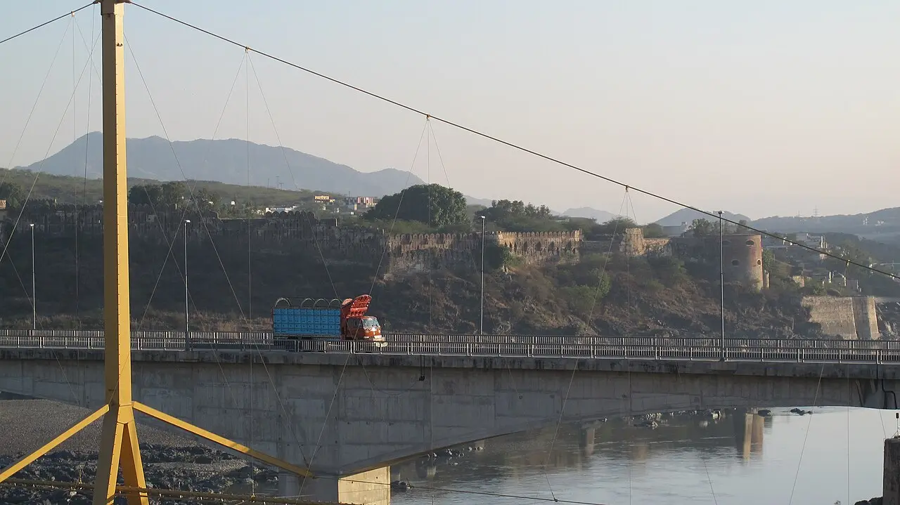
Attock Fort seen from the Khairabad bridge over the Indus and Kabul river, photographed in 2012.
Tan Afridi· CC BY-SA 3.0
The old poets use the name for the river's speed and size. Rahman Baba, in a ghazal on the shortness of life, writes in Raverty's translation:
Like as the river Aba Sind boundeth along in its course,
With such like exceeding precipitation is the progress of life. [2]
Hamid, the Mohmand poet of Mashokhel near Peshawar, turns the river into a measure of his tears:
This river Aba Sind, which appeareth to our view,
Is but a small rivulet, exuded from the ocean of my tears. [2]
Raverty translated both from the poets' Pashto; these English lines are his. See Rahman Baba and Hamid Baba. The Water and Power Development Authority still says the river at Tarbela is "known as the 'Abbasin' or the father of the river". [8]
The river as an edge, and why it is an uneven one
The Pashtun lands are a map of rivers. The Kabul, Swat, Kurram, Tochi and Gomal all run east to the Indus, and the Indus is where they stop.
Elphinstone, the Company envoy who reached Peshawar in 1809, set out the limits of the Afghans' country in his book on the kingdom of Caubul: "The Indus is its boundary on the east, as long as that river continues near the hills," as far as latitude 32° 20′. South of that, he wrote, the plain on the right bank was inhabited by Baluch, though the Sulaiman range and the country at its foot belonged to the Afghans. [3] That is the Derajat described in Dera Ismail Khan and the Derajat.
Khushal Khan Khattak put the same idea in anger at the Yusufzai chiefs who would not join his war against Aurangzeb. In Raverty's translation:
The whole of the other Afghans, from Kandahar unto Attak,
In honour's cause, both secretly and openly, are one. [2]
For Khushal, Attock is where the Pashtun country ends in the east. The poem belongs to the story in Khushal Khan Khattak: poet and chief.
The river was also a political line, and it moved. The 1915 Mianwali gazetteer says that in 1739 the emperor at Delhi surrendered the country west of the Indus to Nadir Shah, and that it passed after Nadir's death to Ahmad Shah Abdali. [6] Caroe records that by 1818 Ranjit Singh's Sikh army held the Indus from Attock to Multan, and that the Durranis kept only Kashmir and some hill country in Hazara east of it. [7] Kabul's later claim to the Pashtun country up to the Indus is told in the Durand Line article.
Attock: Akbar's fort and the crossing
Where the Indus leaves the hills for the Punjab it runs through a narrow gorge, and the Kabul river joins it from the west just above. Raverty's note gives the geography from the Pashtun side: Khairabad, "an old fortress and village on the west bank of the Indus", faces Attock, which stands on the east bank on the high road between India and Khurasan. [2]
Akbar reached the Indus in early June 1581 on his march to Kabul against his brother Mirza Hakim, and, in Caroe's telling, ordered the fort built there, giving the work to Raja Birbal. [7] Floods made a bridge impossible, and the army sat fifty days in the heat of June and July with officers urging a return before it was ferried across in boats. [7] The Punjab gazetteer of 1893 to 1894 says Akbar named the fort Attak Banaras, as Katak Banaras was the great fort at the other end of his empire, and set up the ferry with a colony of boatmen brought from Hindustan, who were given the revenue of a village in Chhachh. [4]
Elphinstone saw the fort in 1809. It stood on a low hillock on the left bank, a parallelogram with polished stone walls, commanded by a rough hill only a ravine away, so that most of the interior could be seen from the other bank. The Indus was about 260 yards broad where his party camped, and in the middle were the rocks Jellalleea and Kemalleea. [3] They are named for two figures of the Roshani movement, Jalala and Kamal, as told in Religion among Pashtuns.
The fort made a Pashtun appointment. Caroe, from the Khattak chronicles, says that when Akbar reached Attock a malik named Akoray was recommended to protect the road westward towards Peshawar, where Yusufzai war parties, resisting the Mughals, were attacking travellers. Akoray took a jagir from a few miles south of today's Attock bridge to Nowshera and the right to the tolls, and founded Akora above the Landai. [7] Caroe doubts the tradition that the Khattak only arrived then. [7] Akoray was Khushal's great-grandfather, and Raverty writes that Shah Jahan confirmed Khushal's fief "together with the charge of protecting the royal road from Attak, on the Indus, to Peshawar". [2] When Aurangzeb came to deal with the rising of 1672, Raverty says, he "remained encamped at Attak" for about two years. [2]
The fort passed to the Sikhs in 1812 or 1813. The gazetteer says Ranjit Singh "surreptitiously seized the fort from the Wazir of Kabul"; Caroe says the rebel governor of Attock gave it up, and that the Durrani wazir Fateh Khan then lost the first pitched battle between Sikhs and Durranis, on the Mansar plain on 13 July 1813. [4, 7] In 1818 Ranjit built a fort at Khairabad on the west bank: "The breeze that blew by Khairabad, for which Khushhal had sighed, now fluttered a Sikh flag." [7] In 1823 he crossed at the old ford near Plund above Khairabad and fought, at Nowshera, tribesmen who had gathered on the Yusufzai bank under a call to jihad. [7] After the Sikh rebellion of 1848 British troops held the fort, and an iron bridge opened in June 1883, which the gazetteer says practically took away the fort's strategic value. [4]
Khushal's breeze to Khairabad
Khushal wrote two poems, in Raverty's translation, to the places on this river. He is away in Hind, and the first asks the morning breeze to carry his greetings:
Gentle breeze of the morn! shouldst thou pass over Khairabad,
Or should thy course lead thee by Sara'e, on the banks of the Sind;
Hail them, again and again, with my greetings and salutations;
And with them, many, many expressions of my regard and love! [2]
The poem goes on: "Cry out unto the swift Aba-Sind with sonorous voice; But unto the Landdaey, mildly and whisperingly say, 'Perhaps, I may drink, once more, a cup of thy waters.'" He then complains that the water of Hind is worse than any hill stream. [2] Caroe quotes the same passage in his own translation, with the cry to "the mighty Aba-Sind". [7]
Raverty calls Sara'e a Khattak town in the hills west of Attock, near the west bank, the birthplace of the poet and the burial place of most of his ancestors. [2] A second poem praises it: "The mercy of the Almighty be upon Akorraey, that selected Sara'e for his home!" It places the Hoddaev range above it, the Nilab and Landay "laid their heads at its feet", and the great road of Hindustan and Khurasan along their banks: [2]
And by Attak lieth its ford, which both kings and beggars hold in dread. [2]
Caroe renders the line "there is the Attock ferry, at which prince and beggar tremble". [7] In these poems the river is not drawn as a frontier. It is the water of the poet's own country.
Pashtuns on both banks
The land west of the river is Pashtun country in the plainest sense: the Khattak of Akora and Khairabad, and the Yusufzai of the Samah, told in the Yusufzai, Mardan and the Yusufzai plain and Charsadda and Hashtnagar. The gazetteers also count Pashtuns east of it.
The Chhachh plain, in Attock tahsil, is a Pashtun settlement that the Rawalpindi gazetteer of 1893 to 1894 calls "allied to those of Yusafzai, on the opposite side of the Indus". It traces the name to a Pashto word, chhechh, "island" or "swamp", and records a belief that these Pashtuns came with Mahmud of Ghazni while the plain was being reclaimed from the river. [4]
Further south, at Makhad, it places Sagri Pashtuns, a branch of the Bangash Khel allied with the Khattak. [4]
Of 887,194 people in the whole district, about 20,000 were returned as speaking Pashto, in the Makhad and Chhachh country. [4]
In Hazara the 1907 gazetteer lists the Utmanzai, a branch of the trans-Indus tribe "invited across the river by the Gujars", at Tarbela and in the Khalsa tract, and says the Utmanzai of Tarbela could talk Pashto, "the ordinary hard Pashtu of the Peshawar border". [5]
In Mianwali the 1915 gazetteer calls the Niazai "Lodi Pathans" from the north-west who settled the Mianwali and Isa Khel tahsils. The Bhangi Khel Khattak of the north-west corner, near Kalabagh, "speak a Pashtu which differs slightly from that of Peshawar", and it says the Niazai of Isa Khel understand Pashto but have given it up. [6]
The Mianwali gazetteer says the Salt Range spur from Sakesar to Kalabagh has "abruptly marked the limits of Pathan expansion to the east". [6] That is an administrator's summary, but it matches the others: Pashtuns settled on both banks from the Kabul river to Mianwali, and the east-bank colonies mostly went over to Punjabi dialects. For the dialects, see Pashto dialects.
Kalabagh, where the river leaves the hills
At Kalabagh the Indus breaks out of the hills. The 1915 gazetteer says the river is "bottled up by the adjoining rocks" and held to a narrow channel until it "breaks through the fetters at Kalabagh and spreads out". [6] This is the site of the proposed dam, argued over since the 1980s. Arab News reports it was proposed in 1984 on the Indus in Mianwali, to generate 3,600 megawatts and store water, at a cost of about 10 billion dollars. [12]
Khyber Pakhtunkhwa's objections come in three parts. The first is flooding: leaders in the province fear the dam would force water back to submerge districts like Nowshera, with drainage trouble at Mardan, Pabbi and Swabi. Sardar Hussain Babak of the Awami National Party told Arab News it would "submerge the Peshawar valley" and was "a non-starter". [12] The second is displacement. A 1999 survey, according to the authority, found 120,320 people would have to move, 42,150 of them in the North-West Frontier Province; a later authority report, as Arab News describes it, counted about 14,500 of 82,500 potentially affected people in KP. [12, 14] The third is consent. The Khyber Pakhtunkhwa, Sindh and Balochistan assemblies each passed unanimous resolutions against the dam, in 1988 and 1994. [14, 15]
The authority answers the objections directly. In August 2012 it told the Lahore High Court that the lake's backwater would end about ten miles downstream of Nowshera, and that a repeat of the great flood of August 1929 would not raise the water at Nowshera even after a hundred years of silting. It said the studies had been reviewed by a Chinese expert and an international panel, and called the objections "baseless". [14, 15] An unnamed official told Arab News in 2025: "The real obstacle is political consensus, not technical feasibility." [12] Hydrologist Hassan Abbas, quoted in the same report, said storage dams absorb only the first wave of a flood, and Muhammad Abdullah Deol of IHE Delft said Kalabagh's 5 to 7.5 million acre-feet is small beside the river's flow of 145 million. [12]
The politics moved again in 2025. After the floods, KP's chief minister, Ali Amin Gandapur of Pakistan Tehreek-e-Insaf, said on 1 September that such projects were needed "for the sake of the future generation" if the provinces' reservations were met. [13] On 2 September his party's Asad Qaiser called that a personal opinion; ANP chief Aimal Wali Khan said Kalabagh was not a solution to recurring floods; a Jamiat Ulema-i-Islam spokesman called it a "dead horse"; and the Peoples Party's Nisar Khuhro said the Sindh, KP and Balochistan assemblies had all opposed it. [13] The federal communications minister welcomed Gandapur's words and said it should be built with the consent of all provinces. [13]
KP has a related grievance upstream. In February 2013 its provincial government demanded a review of the Ghazi Barotha hydropower project, saying the canal's design had been changed and that tube wells in Swabi had dried up. [16]
Tarbela: the dam and the people it moved
The authority places Tarbela on the Indus in Swabi district, 130 kilometres north-west of Islamabad. It says the contract was awarded on 14 May 1968, that building ran from 1968 to 1976 as part of the Indus Basin Project under the Indus Waters Treaty, and that the reservoir is 81 kilometres long with a design gross storage of 11.6 million acre-feet; its existing gross storage is now given as 7.99 million. [8]
The people the dam displaced are not on the authority's page. Dawn reported in May 2002 that about 90,000 families were displaced when the dam was built, and that 1,300 had still not been given plots 27 years later. [9] The North-West Frontier government had just taken 112 kanals at Oghi, in Mansehra, for 225 plots, after what Dawn called "several years of wrangling" with the authority, and it did so under pressure from the World Bank, whose loan for the Ghazi Barotha project required the resettlement to be finished. [9, 10] President Musharraf's repeated instructions to Sindh and Punjab to give land, Dawn said, "did not yield desired results". [9]
A Dawn feature of August 2016, from the Swabi towns beside the dam, found that "despite a nearly $500 million resettlement package allocated for those affected by the original dam project, many have not been compensated". Villagers displaced when it was first built still lived a few miles away. [11]
Common questions
What does Abasin mean?
Abasin (اباسين) is the Pashto name of the Indus. Raverty's 1860 dictionary glosses it as "the Father of Rivers", from abā, "father", and sīn or sind, "a river". Rahman Baba, Hamid and Khushal Khan Khattak all use it in verse.
Who built Attock fort and when?
Akbar ordered it in early June 1581, on his march against his brother Mirza Hakim in Kabul, and gave the work to Raja Birbal, according to Caroe. The Punjab gazetteer says he named it Attak Banaras and set up the ferry.
Is the Indus the eastern border of the Pashtun country?
Only in part. Elphinstone gave the Indus as the Afghans' eastern boundary while it runs near the hills, and Khushal Khan wrote of the Afghans "from Kandahar unto Attak". But Pashtun settlements also lie east of it, at Chhachh, Makhad, Hazara and Mianwali, though many there had given up Pashto by the early 1900s.
Why does Khyber Pakhtunkhwa oppose the Kalabagh dam?
Its leaders fear flooding of Nowshera and the Peshawar valley, waterlogging in Mardan and Swabi, and the displacement of villagers; the province's assembly has passed a resolution against it. The Water and Power Development Authority says the objections are baseless and that the lake's backwater would end about ten miles below Nowshera.
Pictures (4)
Gallery
4 images
Attock, the fort and the pontoon bridge over the Indus, in a mid-19th-century watercolour by an unknown British School artist.
Watercolour of Attock Fort by Charlotte Canning, 2 March 1860.
The Indus at Kalabagh, in Isa Khel tehsil, with the red hills of the Salt Range, May 2018.
Tarbela Lake, Haripur District, Khyber Pakhtunkhwa, photographed in 2014.
Sources
Colonial records
Gazetteers, glossaries and reports by British officers and travellers, 1815–1947. They describe the tribes as their authors found them, and for the uses of the colonial government.
- Back to textH. G. Raverty, A Dictionary of the Pukhto, Pushto, or Language of the Afghans (London: Williams and Norgate, 1860), p. 3 (entry abā-sīn) and the entry sīnd
The Pashto spelling and gloss of Abasin, and sind as "a river". Page 3 read from the page image; the sind entry (landay sind, the Kabul river) read from the OCR text.
- Back to textH. G. Raverty, Selections from the Poetry of the Afghans (London, 1862), pp. 25, 104, 143-144, 150, 193-194 and 247-248
Raverty's translations of Rahman Baba, Hamid and Khushal Khan, his notes on Aba-Sind, Nilab, Landay, Khairabad and Sara'e, and his memoir of Khushal. Read in the OCR text.
- Back to textMountstuart Elphinstone, An Account of the Kingdom of Caubul, vol. I (London, 2nd edn), introduction p. 118 and p. 150
The fort of Attock in 1809 and the eastern boundary of the Afghans' country. Read in the OCR text.
- Back to textGazetteer of the Rawalpindi District, 1893-94 (Lahore, 1895), pp. 107 and 260 and the chapter on the people (language)
Attock fort, ferry and bridge; the Pashtun settlements at Chhachh and Makhad; the count of Pashto speakers. Read in the OCR text.
- Back to textGazetteer of the Hazara District, 1907 (Lahore, 1908), pp. 24 and 41
The Utmanzai of Tarbela and the Khalsa tract and their Pashto. Read in the OCR text.
- Back to textPunjab District Gazetteers, vol. XXX A, Mianwali District, 1915, pp. 9, 24-26, 57 and 60
The Indus at Kalabagh, the surrender of 1739, the Niazai and Khattak of Mianwali and their language. Read in the OCR text; page numbers follow the running heads, which are garbled in places.
Modern scholarship
Books and papers by historians, anthropologists, linguists and geneticists.
- Back to textOlaf Caroe, The Pathans, 550 B.C.-A.D. 1957 (London: Macmillan, 1958), pp. 207-208, 211-212, 243-244, 289-290 and 294
Akbar and the building of Attock, Akoray's commission, Caroe's translation of Khushal's Khairabad poem, the Sikh capture of Attock and the fort at Khairabad. Caroe was a British frontier official; his views are attributed to him. Read in the OCR text.
Reference works
Encyclopaedias, country studies and museum records.
- Back to textWater and Power Development Authority, "Tarbela Dam" (project page)
Location, dates, reservoir figures and the name Abbasin. Read in full.
News and magazines
Newspapers, broadcasters and magazines, for recent events and life today.
- Back to textDawn, "Land acquired for affected people: Tarbela Dam project", 20 May 2002
Displaced families, the Oghi plots and the Sindh and Punjab instructions. Read in full.
- Back to textDawn, "WB wants Tarbela Dam victims rehabilitated", 25 May 2002
The World Bank condition tied to Ghazi Barotha. Read in full.
- Back to textDawn, "The dam stained with blood", 23 August 2016
The resettlement package and uncompensated villagers around Tarbela. Read in full.
- Back to textArab News, "Pakistan flood crisis revives row over long-stalled Kalabagh Dam project", September 2025
The project, KP's objections, the authority's report, ANP's view and independent experts. Read in full.
- Back to textDawn, "PPP, PTI leaders take exception to KP CM Gandapur's 'personal' support for Kalabagh Dam", 2 September 2025
The 2025 reactions of the PTI, ANP, JUI-F and PPP. Read in full.
- Back to textThe Express Tribune, "Kalabagh Dam: Objections based on lack of information, says WAPDA", August 2012
The authority's reply to the Lahore High Court: relocation numbers and the Nowshera backwater claim. Read in full.
- Back to textDawn, "Wapda tells LHC: Provinces' objections to KBD baseless", 8 August 2012
The provincial assembly resolutions against the dam. Read in full.
- Back to textDawn, "KP demands review of Ghazi Barotha project", 22 February 2013
KP's complaint about the Ghazi Barotha canal. Read in full.
Related articles
- Charsadda and Hashtnagar: ancient Pushkalavati and the Swat river plain
- Dera Ismail Khan and the Derajat: the Daman plain and the Powindah road
- Hamid Baba (Abdul Hamid Mohmand): the Pashto poet of Mashokhel
- Khushal Khan Khattak: poet and chief
- Mardan and the Yusufzai plain: Hoti, the Guides, Takht-i-Bahi and Shahbaz Garhi
- Rahman Baba: the Pashto Sufi poet
- Religion among Pashtuns: Islam, Sufism and the Roshaniyya
- The Durand Line, 1893
- The Khattak: Pashtun tribe of Karak, Kohat and Nowshera
- The Pashtun lands: mountains, rivers and passes
- The Yusufzai: the Pashtun tribe of Swat, Buner and the Mardan plain
Improve this article
- Suggest an edit
Know something we missed, or a better way to put it? Suggest a change; an editor reads it before it appears.
- Report an error
Think a fact, date or name is wrong? Tell us which and why, with a source if you have one.
- Add a source
Have a book, paper or document that backs up a claim? Add it.
- Translate into Pashto
Read both Pashto and English? Help put this article into Pashto.
Noticed a mistake or a missing source? Here's how we correct things


